Infragistics Ultimate UI for WPF Geographic Map
Create detailed, customizable geographic maps within WPF applications.
- Custom shape templates enable tailored map visualizations.
- Supports multiple geographic tile layers including Esri ArcGIS imagery.
- Advanced series types like Proportional Symbol and Scatter Area Plots for data insight.

Prices from:
| Available in | |
|---|---|
| Infragistics Ultimate UI for WPF | Loading |
| Infragistics Professional | Loading |
| Infragistics Ultimate | Loading |
Custom Shape Templates
Define and render geographic shapes using customizable templates, allowing highly tailored map visuals that fit diverse application needs.
Polyline and Polyshape Rendering
Draw complex routes and areas on maps with support for polylines and polyshapes, adding rich geographic detail to visualizations.
Map Progression Feature
Visually represent temporal or sequential map data, enabling applications to display changes or progressions over time effectively.
Scatter Area Plots
Display thousands of data points across regions with smooth color interpolation, useful for visualizing density or magnitude data like precipitation.
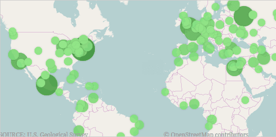
Proportional Symbol Series
Use differently sized and colored symbols to represent geospatial values, allowing for quick visual comparisons of data intensity across locations.
Geographic Tile Series with Multiple Layers
Overlay multiple geographic imagery layers with options for transparency and cutouts, including integration with Esri ArcGIS 256x256 Mercator tile sets.
Map Overview Pane
Integrate an intuitive overview pane for easy navigation and zooming within detailed maps, improving user interaction and spatial orientation.
Triangulation Support and ITF Files
Precompute and load triangulations of geospatial data points for efficient rendering, with the ability to save and load this data using ITF file formats.
Product Compatibility
Review the details below to ensure this product is supported within your environment.
Component Type
- .NET
.NET Version
- .NET 10 LTS
- .NET 9 STS
- .NET 8 LTS
- .NET 4.8 or earlier
.NET Platform
- .NET Assembly
- .NET WPF
IDE Support
- Visual Studio
About Infragistics
Infragistics, founded in 1989 and headquartered in Cranbury, New Jersey, has established itself as a global force in UI/UX development, serving software professionals in over 100 countries. It is widely recognized for its comprehensive libraries and frameworks supporting web, desktop, and mobile platforms, including solutions tailored for .NET, Angular, React, and other leading technologies. With offices spanning Europe, Asia, and South America, Infragistics delivers components that enable efficient application development and rich user experiences. Its commitment to innovation and customer satisfaction positions it as a trusted partner for developers and organizations worldwide seeking quality and flexibility in their digital projects.

As official and authorized distributors since 1996, ComponentSource supplies you with legitimate licenses directly from Infragistics.