Altova MobileTogether 5.4

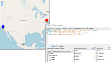
새로운 Geolocation Map 컨트롤을 사용하여 앱에 직접 맵을 표시할 수 있습니다.
6월 13, 2019
신규 버전

기능

Geolocation Map Control

  • Adding to existing geolocation functionality in MobileTogether, a new Geolocation Map control lets developers display a map directly in their app. The map can display the street, satellite, or hybrid view of the specified geographic area. Points of interest in the area can be shown by different colored markers in the map.
  • Viewport, Control Width, and Control Height properties provide flexibility for controlling how the map is displayed.
  • The control has an OnGeoMapMarkerClicked event, which lets the app developer define actions to perform when a particular marker is clicked by the user.
  • New variables and extension functions have been created to support map functionality:
    • $MT_GeolocationMapMarker: dynamic variable that contains information about the marker last clicked or tapped by the user.
    • mt-geo-map-marker: creates a marker on a map.
    • geolocations-bounding-rectangle: creates a bounding rectangle around a set of submitted geolocations.

Record-video Action

  • The new Record-video Action makes it possible to record video from a MobileTogether app.
  • Developers can define triggers that start the device’s video recording app and specify:
    • The name and location of the video file to save when the recording ends.
    • The maximum recording duration or file size.
    • The picture quality of the video recording.
Geolocation Map Control

Altova MobileTogether

모든 플랫폼을 위한 앱 개발.

궁금한 점이 있으세요?

Altova 사 제품 라이선스 담당자와 라이브 채팅