


官方供应商
我们作为官方授权经销商,直接提供超过200家开发厂家所发行超过1000个的产品授权给您。
查看我们的所有品牌。
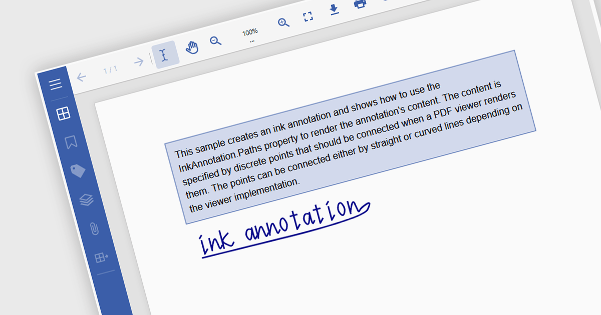
Freehand Draw, also known as Ink Annotation, in ASP.NET Core PDF Viewer controls allows users to add freeform, hand-drawn annotations directly onto PDF documents. This feature mimics natural handwriting or sketching by enabling input through mouse, touch, or stylus, making it especially useful for scenarios requiring personal notes, signatures, or diagrammatic feedback. The annotations are embedded as part of the PDF, ensuring they remain accessible and visible across different platforms and viewers. It is commonly used in applications where document review or digital signing is required, enhancing interactivity and collaboration within PDF-based processes.
Several ASP.NET Core Assembly PDF Viewer components offer support for Freehand Draw/Ink Annotation including:
For an in-depth analysis of features and price, visit our comparison of ASP.NET Core Assembly PDF Viewer Components.
ABP Platform is a comprehensive framework designed to accelerate the development of enterprise software solutions by offering an opinionated architecture built on best practices for .NET and ASP.NET Core. It equips developers with the essential infrastructure, production-ready startup templates, pre-built application modules, and modern UI themes needed to build robust, scalable, and maintainable applications. With powerful tooling, detailed guides, and extensive documentation, ABP Platform improvs implementation, reduces repetitive tasks, and ensures consistency across projects. Ideal for organizations seeking to enhance productivity and maintain high-quality standards, it enables teams to focus on delivering business value while the platform handles architectural complexity and automation.
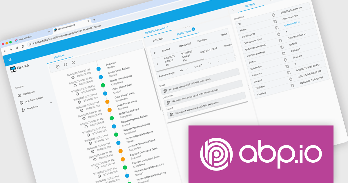
The ABP Platform 10.0 update introduces the Elsa Workflow module, giving developers a fully integrated way to design and execute visual, event-driven processes within both monolithic and microservice architectures. With built-in support for Elsa Studio, developers can model and manage behavior through a hybrid UI while relying on ABP to handle execution, state management, and service interactions, resulting in a more consistent and maintainable approach to orchestrating application processes.
To see a full list of what's new in version 10.0.0, see our release notes.
The ABP Platform is available as a Team, Business or Enterprise license, which entitles developers to use the platform's Pro features and provides software updates and technical support for 1 year. See our ABP Platform licensing page for full details.
For more information, visit our ABP publisher page.
Fiddler Everywhere by Telerik is a cross-platform web debugging proxy designed to help software developers monitor, inspect, and modify HTTP and HTTPS traffic between their applications and the internet. It provides comprehensive tools for troubleshooting network-related issues, analyzing application performance, and testing web applications under different network conditions, streamlining the development and debugging process.
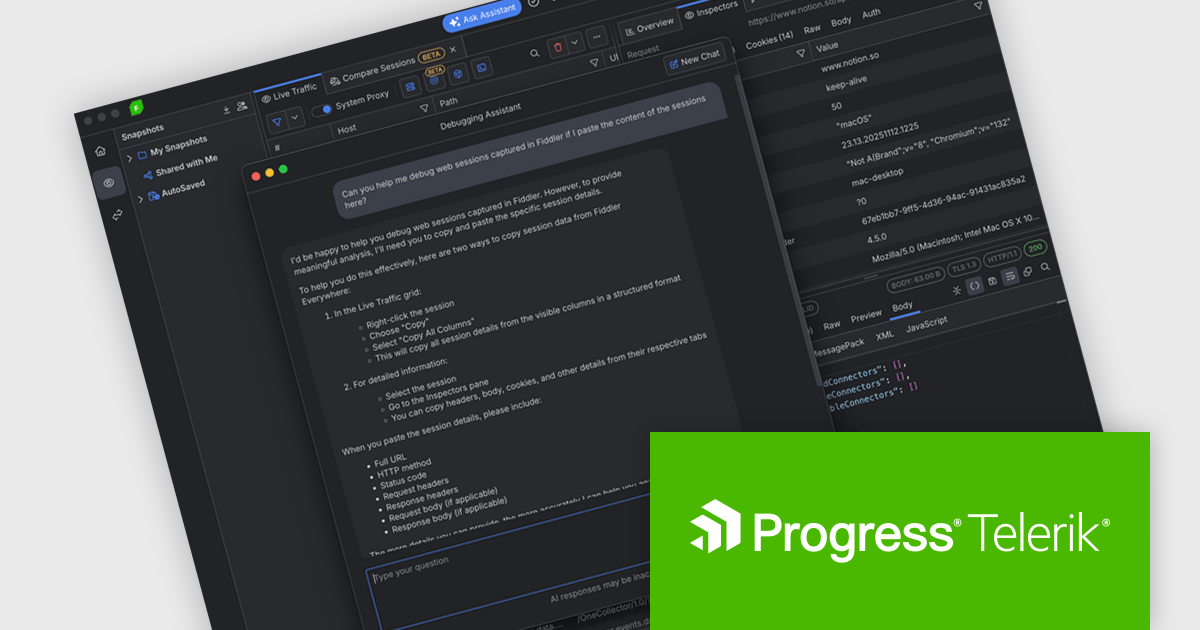
The Fiddler Everywhere v7.5.0 update introduces a new Debugging Assistant that helps developers debug HTTP and HTTPS traffic faster and with more confidence by delivering AI powered answers directly inside the tool. It interprets captured sessions, highlights potential issues, and provides clear explanations of anomalies so you can understand what is going wrong without manually inspecting every request and response. The assistant can also answer questions about Fiddler Everywhere features and settings, helping you discover and apply the most effective techniques for your scenario.
To see a full list of what's new in v7.5.0, see our release notes.
Fiddler Everywhere is licensed per developer and has two licensing models: an annual Subscription License and a Perpetual License. The Subscription license provides access to the latest product updates, technical support, and exclusive benefits for a flat annual fee, and must be renewed to continue using the software. The Perpetual license is a one-time purchase granting access to the current released version and includes a one-year subscription for product updates and technical support. After this initial period, users can choose to renew the subscription element to continue receiving updates and support; otherwise, they may continue using the installed version available during their active subscription term but will forgo future updates and support. See our Fiddler Everywhere licensing page for full details.
For more information, see our Fiddler Everywhere product page.
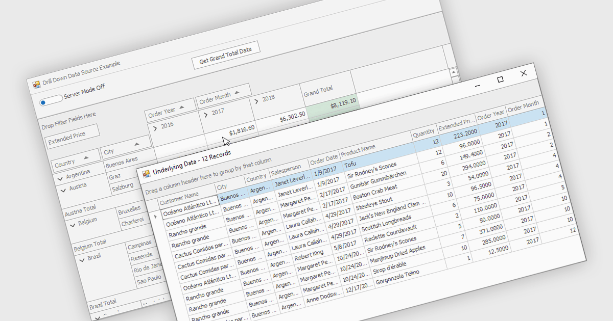
Drill-down capability within a grid control enables users to move from summary data to increasingly detailed records within the same interface, creating a smooth and focused exploration experience. It improves productivity by reducing screen changes and extra queries, helps users spot patterns and exceptions more quickly, and keeps complex information clearly organized. Typical use cases include reviewing sales by region, then by city and customer, analyzing financial summaries that open into individual transactions, or exploring product inventories from category to specific item.
Several .NET WinForms grid controls offer drill-down capability including:
For an in-depth analysis of features and price, visit our .NET WinForms grid controls comparison.
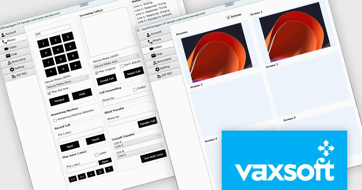
VaxVoIP MS Windows SIP Phone SDK by VaxSoft is a comprehensive software development kit designed to help developers build, customize, and distribute SIP-based VoIP softphones for Windows. It provides all the essential tools and sample code needed to create professional, feature-rich communication applications with ease. With full control over the user interface and functionality, developers can integrate SIP capabilities into their software while maintaining complete flexibility over design and branding.
From enterprise communication platforms and call center applications to custom-branded softphones for service providers, the SDK supports a wide range of use cases. Its SIP integration and developer-friendly structure enable rapid delivery of reliable communication tools that enhance collaboration and strengthen brand identity.
VaxVoIP MS Windows SIP Phone SDK is licensed under a single software brand product license, allowing use for one software application with limited distribution rights. Developers may distribute compiled applications to end users, but redistribution of the SDK or its source code is prohibited, and each license is tied to a specific service provider or client. See our VaxVoIP MS Windows SIP Phone SDK licensing page for full details.
For more information, visit our VaxVoIP MS Windows SIP Phone SDK product page.
联系电话: (888) 850 9911
传真: +1 770 250 6199


